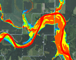
In the summer of 2013, Iowa Natural Heritage Foundation (INHF) launched the Floodplain Outreach Program. This program develops flood plain maps that show areas that are prone to flooding and scour erosion. With these maps, farmers and ag retailers can identify those flood plain acres that are expected to flood one half, one fifth, and one tenth of the years farmed.
According to the Iowa DNR, flood plain mapping is the creation of new, comprehensive, accurate flood plain maps for Iowa cities and counties. The program has the potential to let many Iowans know if their property is at risk for flooding and how often it will flood. The maps will show the boundaries of flooded areas for the 2, 5, 10, 25, 50, 100, and 500 year rainfall events.
The raw flood plain mapping data cannot be used for flood insurance purposes. However, the Iowa DNR has enlisted the help of FEMA and flood plain mapping consultants to create additional Flood Insurance Rate Maps.
Through the Floodplain Outreach Program, INHF hopes to facilitate flood plain management education. The program will instruct farmers on how to best utilize information made available by the new flood plain maps to help preserve Iowa’s valuable landscape.
It is estimated the maps will be released to all 99 Iowa counties over the next five years. In that timespan, INHF is seeking grants to organize public informational meetings statewide to explain the impact of these maps on conservation and effective farming practices. A two-year grant has been awarded by the National Fish and Wildlife Foundation.
These data layers can be downloaded as PDF files or GIS files at:
http://ifis.iowafloodcenter.org/ifis/newmaps/risk/download.php
For more detailed information on the flood plain mapping technology, visit the Iowa DNR website at: http://www.iowadnr.gov/InsideDNR/RegulatoryLand/FloodPlainManagement/FloodPlainMapping.aspx
Or for more information, contact:
Duane Sand
Floodplain Outreach Coordinator
515-288-1846, ext. 26
dsand@inhf.org
 4Rs Are Not Enough
good points, well-stated. thanks for putting this out there —