Fifty years! Yes, that’s right. At the current rate it will take 50 years to design and install all the grassed waterways needed in Iowa. And this timetable is being generous. The 50 years doesn’t even account for maintenance, repair, and replacement of these grassed waterways after their normal 10-15 year lifespan.This is not acceptable, especially when you consider all conservation practices like ponds, wetlands, water & sediment control basins, terraces, no-till, and cover crops are on this same timetable. Please note, this is not a …
As simple as one, two, three
Sometimes it is the simple things that can make a big difference. Take contouring, for example. It’s easy; so easy in fact that we often overlook it when we consider it in the context of conservation technology. I staked a lot of contour lines for farmers when I was a NRCS Soil Conservationist in the 1980’s. It was easy; just me, my hand level, and a fist full of flags. But it was also time consuming. It took hours to stake 160 acres of cropland, especially when I tried to minimize point rows. Today, my local conservation district no longer …
Exciting possibilities ahead using 3D Machine Control – Part 2
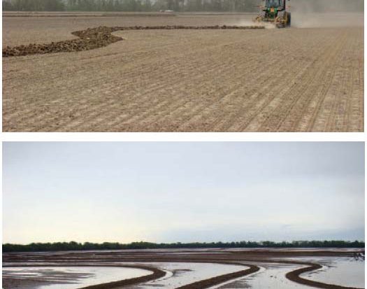
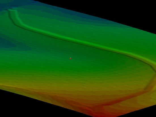
I asked the question in my last post, “What good is Precision Conservation if it doesn’t help us apply conservation better and faster?” One of the major limiting factors in getting more structural practices on the land is the short construction season. What conservation field office staffer or contractor wouldn’t love to get twice as many structures built in the same amount of time? I do believe that fully automated 3D machine control will be one of the game changers that conservationists have been looking for; that is, if private businesses …
Exciting possibilities ahead using 3D Machine Control
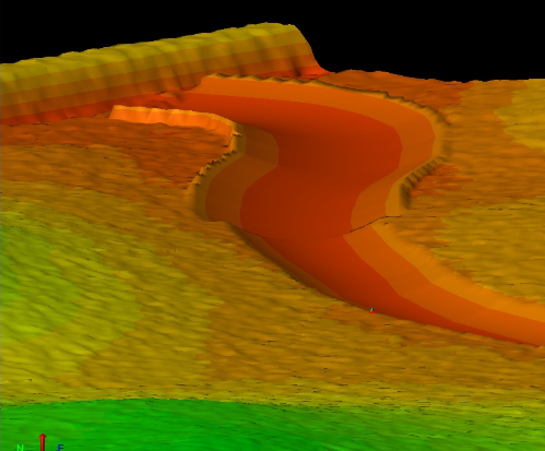
What good is Precision Conservation if it doesn’t help us apply conservation better and faster? We should expect that a part of Precision Conservation should simplify and automate the routine and the mundane, so the professional conservationists can engage in meaningful conservation planning. My new favorite Precision Conservation topic is fully automated 3D machine control. This will be one of the game changers we have been looking for, if private businesses and government entities can work together. Recently, I worked with Ryan Murguia of …
Let’s start taking the other 50% of soil erosion seriously.
I recall hearing a business maxim some years ago: “What gets measured gets done.” In other words, if there is no standard by which to measure something, it becomes a low priority. Unfortunately, this seems to be the case with soil erosion.For years, resource professionals have had the RUSLE2 soil erosion model to predict the amount of sheet and rill erosion that occurs on a farm. Sheet and rill erosion is caused by a shallow sheet of rainwater that runs across the land. This picks up and transports soil particles already detached by a raindrop …
RTK vs. LiDAR – or – RTK & LiDAR
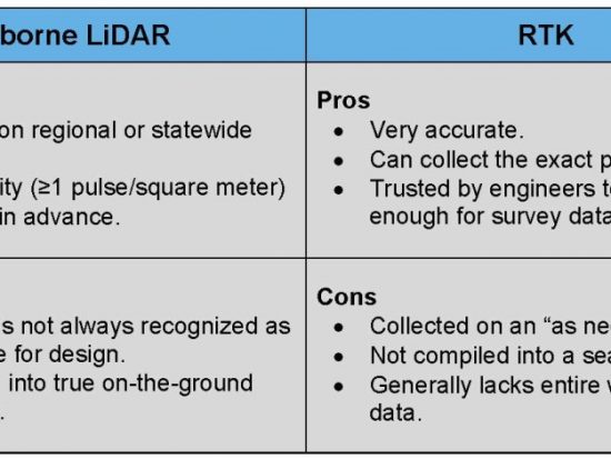
One of the most important data layers in Precision Conservation is the elevation layer, or topographic layer. But, there is one big question that needs to be answered. What is the best data source for Precision Conservation; LiDAR or RTK? The world of elevation data is changing so quickly it is hard to keep up. But even with all of the options the two most common types of elevation data, for conservation planning, are airborne LiDAR and RTK. Given that, which should we choose?On one hand, we have airborne LiDAR data that is collected on a …